At this year’s 5×5: The Public Safety Innovation Summit hosted by NIST PSCR and the FirstNet Authority in San Diego, IamResponding President Daniel Seidberg spoke with IWCE‘s Urgent Communications Editor Donny Jackson about how IamResponding supports field responders, including our partnership with RapidSOS.
Watch the full interview here or read their conversation below. To find out more about IamResponding’s powerful tools and features, visit www.iamresponding.com.
JACKSON: For those who may not be familiar, tell us a little bit about IamResponding.
SEIDBERG: IamResponding has been around since 2006. It’s used today by over 10,000 agencies across North America, fundamentally for notifications, alerts, mapping—to know where to go and how to get there—and situational awareness of what you’re going to find when you get there.
We take redundant pathways for notification of this, both from CAD feeds and from the radio pager feed. Today, we provide this data to close to half a million field responders today. That’s the foundation of what IamResponding is.
We’re also now in a partnership with RapidSOS, an intelligent safety platform that is receiving data from over 500 million connected devices. RapidSOS is already providing a tremendous amount of data at the ECC level, which is great, but it’s particularly valuable to those in the field.
The most important piece of that data is location. Where do I need to go? Today, over 80% of all 911 calls are made from mobile devices. Historically, you could only get a triangulated location with tremendous inaccuracy, in addition to incidents with poorly addressable or non-addressable locations.
If you think about motor vehicle accidents on a highway, there’s no location. Parks, woodland, large schools, large industrial complexes, sports complexes. The building we’re in today—if I called 911 from where I’m standing right now, EMS or fire is going to show up at the front door, but they won’t know where I am, right?
JACKSON: Correct.
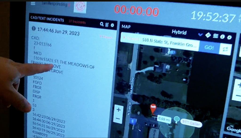
SEIDBERG: With the RapidSOS platform, we have accurate location information from all wireless 911 callers. Today, when we share that data with field responders, we’re providing not only the location that CAD is sending to them, but also the location of where that 911 call is coming from, including breadcrumbs of that caller for the duration of their 911 call.
So now when you’re responding at, say, an apartment complex, you know exactly where that 911 call is coming from so you can get to the person in need faster, for a better outcome.
JACKSON: Okay, that sounds great. Can you show us what that looks like?
SEIDBERG: Here is a perfect example. This is a medical call coming in at 510 North State Street. The IaR pin here is where CAD is sending the agency—as you can see, it’s an apartment complex. But we know where the caller is and what the uncertainty radius is. If they had been moving around while they were making that call, you’d see the breadcrumbs so you could find them.

We had a call recently in one of our neighboring jurisdictions in a 2,000 acre park—a lost, injured hiker. The only location CAD would ever send to is the park entrance, so historically, that would be a multi-hour search and rescue operation. With IamResponding, they could see where the 911 caller was located and what trail she was on. They were able to get directly to her, get in, get out, and get her to the hospital in under half an hour’s time.
JACKSON: Wow.
SEIDBERG: So tremendous difficulty is resolved when we know the foundational location information. And location is just the core piece of what we’re providing. We’re also providing telematics data, building alarm sensor data—so what are you going to find? What’s actually happening?
JACKSON: For the location, are you also showing Z-axis?
SEIDBERG: For 911 callers on mobile devices, we’re also getting elevation plus the XY on the location.
JACKSON: Wow, that’s powerful stuff.
SEIDBERG: The historical 911 call is: “What’s your name? What’s your emergency?” When you call in from your mobile phone, I should already know what your name is. I should already know what language you speak because your phone is set to a particular language.
If I can know the who, the language, and the where before anybody’s even speaking, I’ve got the most critical core data that I need. That’s all now being provided to those in the field so they can get to callers faster, help more effectively, and get a better outcome.
JACKSON: So IamResponding was providing a lot of this information anyway, but now because of the data sources that RapidSOS has access to, you’re able to do more of it?
SEIDBERG: It’s tremendously enhanced situational awareness. RapidSOS is ingesting data from over 500 million connected devices. Being able to deliver that data into the field, in addition to ECCs, is what’s really transforming emergency response.
JACKSON: If I’m an ECC, is there anything I need to be able to do to leverage this?
SEIDBERG: Most ECCs are already using RapidSOS. If your agencies are not using IamResponding, we just need to talk to you about that. We do free trials to get agencies up and running, and we run a very simple integration with RapidSOS where we merge your CAD data with their data and deliver it down into the field.
JACKSON: Fantastic stuff. Well congratulations, Daniel, and please let us know how IamResponding progresses going forward.
SEIDBERG: Thank you very much for your time.
Note: This conversation has been edited and abbreviated for publication.


